India is formally known as the Republic of India and it comprises of twenty-eight states and nine union territories. It is second most populated country in the world and is also the world’s largest democracy.
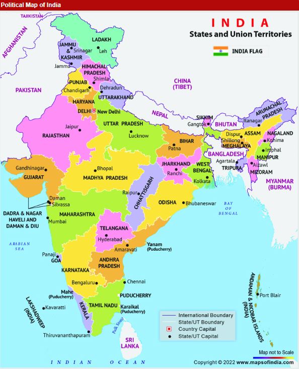
Political And Physical Map of India 2024
The political map of India depicts the states and capital cities of India as and the countries bordering India. India is located in southern asia with Bay of Bengal in the east and Arabian sea in the west. It is located on the geographical coordinates of 20 degree North and 77 degree East latitude and longitude respectively. The country covers an area of about 1.269 million sq.m (3,287,590 sq.km) Kanchanjunga, located at an elevation of 28,209 feet. It is the highest point in India.
The country’s coastline measures 7,517 kilometres in length out of which 5,423 kilometres belong to peninsular India and 2,094 kilometres cover the Andaman, Nikobar and Lakshadweep island chains.
Broadly, India is divided into six major zones :-
1. East India, 2. West India, 3. North India, 4. South India, 5. Northeast India and 6. Central India.
Political And Physical Map of India 2024
1. East India :-
The eastern India includes the states of Bihar, Jharkhand, Orissa and West Bengal and also Andaman and Nicobar Islands which is a Union Territory. The Eastern zone covers a total area of 418,323 sq km. Bengali is the dominant language in the state of West Bengal, whereas Odia and Hindi are the principal languages in the states of Orissa and Jharkhand respectively. English, Maithili, Nepali and urdu are some of the other languages that are spoken in Eastern India.
2. West India :-
The Western part of India covers a total area of 508,0522 sp. km. Some of the states in western India are Gujarat, Goa and Maharashtra. Daman an Diu and Dadra and Nagar Haveli are the Union Territories. Mumbai is the financial capital of India, and also Mumbai is the capital of Maharashtra. The states of western India have a prosperous economy with relatively high standards of living. Official languages of the states in Western India include Marathi, Gujarati, Konkani and English.
3. North India :-
The North Indian states are :- Himachal Pradesh, Utter Pradesh, Uttarakhand, Punjab and Haryana, Delhi (National Capital Territory) and Chandigarh are the Union Territories. As per the new bill passed in Parliament, the state of Jammu and Kashmir has been divided into two Union Territories. Of Jammu and Kashmir and Ladakh. The most populous cities of North India are New Delhi, Jaipur, Lucknow and Chandigarh. The economy of Northern India is growing at a fast pace.
4. South India :-
Southern India covers the states of Tamil Nadu, karanataka, Kerala, Andhra Pradesh and Telangana and the Union Territories of Lakshadweep and Puducherry. Over 19.31% of India’s total area is occupied by these staes and union territories. Bengaluru is the capital of karnataka. is also known as the ‘Silicon Valley of India’ because it is the country’s leading exporter in IT sector. The most populous cities of South India include Bengaluru, Hyderabad, Chennai, Coimbtore, Cochin and Mysore.
5. Northeast India:-
North East India includes Arunachal Pradesh, Assam, Meghalaya, Tripura, Mizoram, Manipur, Nagaland and the Himalayan state of Sikkim. There is great ethnic and religious diversity in these states.
6. Central India :-
The Central zone of India primarily comprises Madhya Pradesh and the newly formed state of Chhattisgarh.
Physical Map of India
A Physical map of India depicts all the physical features of the country. The topographical features of India are quite varied. These maps help us understand the topographical features of India. They help us locate physiographic regions in the country which include:-
- The Himalayan Mountain Range.
- The Indian Peninsula.
- The Indo Gangetic Plains.
- The Western and Eatern Ghat Mountain Ranges
- Tjhe Karakoram Mountain Range.
- The islands Costal Plains.
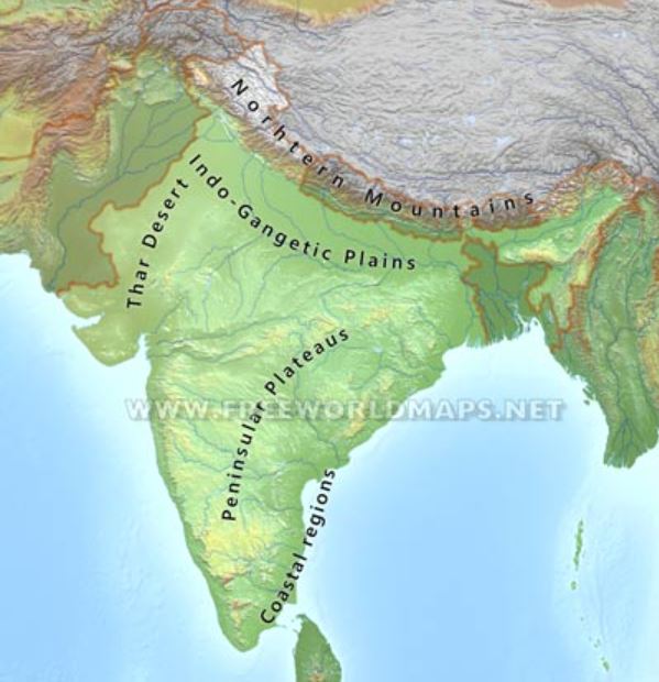
This map also highlights the prominent rivers and streams of the country, such as the Yamuna, Ganga, Sutlej, Jhelum. Indus and Godavari rivers, as well as seas like the Bay of Bengal, The Indian Ocean and the Arabian Sea.