A political map of the world represents the names and location of all the countries of the world.
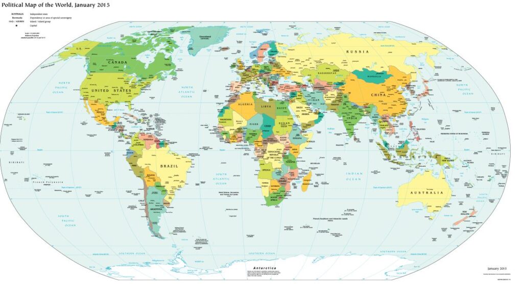
A Political world map depicts the territorial boundaries of all the countries. While some of the boundaries are created by geological features such as mountains and rivers, others are politically demarcated. The map follows the globally accepted standards for national boundaries and gets updated with the latest variations.
Some of the largest independent nations in the world are the Russian Federation, People’s Republic of China, The United States of America, Canada, Australia, India, Brazil, Saudi Arabia and Argentina.
The smallest nations include Vatican city, Monaco, Andorra and Singapore. all these nations can be represented on the political map.
A Mercator projection is one which is most commonly used for school-based maps. A political map is designed to show governmental boundaries of countries and states, the location of some major cities as well as the significant water bodies. Bright colors are used to help viewers locate the borders and countries, which are very hard to distinguish otherwise.
Physical map of the World 2024:-
A physical map of the world is terrain relief image of the world with the boundaries of major countries drawn with white lines. It includes the names of the world’s oceans, major baysn gulfs and seas. Lower elevations are marked with dark green color. There is a gradient from green to dark-brown to grey as the elevation increases. This allows the major mountain ranges and lowlands to be clearly visible.
Physical maps represent landforms, water bodies and other important geographical features such as mountains, deserts and lowlands, as well as lakes, rivers and oceans. Physical maps of the world highlight features like continents, oceans and mountains.
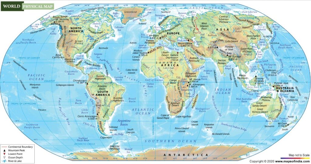
The physical map of the world depicts seven major water bodies :-
- The Pacific Ocean,
- The Atlantic Ocean,
- The Indian Ocean,
- The Arctic Ocean,
- The Mediterranean Sea,
- The Caribbean Sea,
- The Gulf of Maxico.
The physical map of India is also illustrates the major mountain ranges of the world :-
- The Himalayan Mountain Range,
- The alps Mountain Range,
- The Atlas Mountains Range,
- The Andes Mountain range and
- The Rockies Mountain Ranges.
Your site visitors, especially me appreciate the time and effort you have spent to put this information together. Here is my website Webemail24 for something more enlightening posts about PR Marketing.
Hi…. thanks for comment….
situs slot situs slot situs slot
Hmm it appears like your site ate my first comment (it was extremely long) so I guess I’ll just
sum it up what I had written and say, I’m thoroughly enjoying your blog.
I too am an aspiring blog writer but I’m still new to
everything. Do you have any recommendations for novice blog writers?
I’d really appreciate it.
HI…..
When someone writes an piece of writing he/she maintains the plan of a user in his/her brain that how a user can be aware of it.
Thus that’s why this paragraph is outstdanding. Thanks!
Thanks sir ….
I think this is among the most significant info for me.
And i am glad reading your article. But wanna remark on some
general things, The web site style is great, the articles is really great :
D. Good job, cheers
Thanks sir ….
Wow! This blog looks just like my old one! It’s on a totally different subject
but it has pretty much the same layout and design. Great
choice of colors!
thanks sir…
This site was… how do you say it? Relevant!!
Finally I’ve found something which helped me. Many thanks!
Thanks sir ….
This article is in fact a nice one it assists new net visitors, who are wishing for
blogging.
Thanks sir ….
We are a gaggle of volunteers and starting a brand
new scheme in our community. Your web site offered us with useful info to work
on. You have done an impressive activity and our entire community might
be thankful to you.
Thanks sir ….
I was wondering if you ever thought of changing the
structure of your blog? Its very well written; I love what youve got to say.
But maybe you could a little more in the way of content so people could connect with
it better. Youve got an awful lot of text for only having 1 or two images.
Maybe you could space it out better?
If some one needs expert view concerning blogging and site-building afterward i advise him/her to visit this
web site, Keep up the good work.
Thanks sir ….
Thank you for the good writeup. It in reality was once a leisure account it.
Glance advanced to more introduced agreeable from you!
However, how can we keep up a correspondence?
Thanks sir ….
For most recent information you have to visit world-wide-web and on internet I found this web site
as a best web site for hottest updates.
Thanks sir ….
Actually when someone doesn’t know after that its up to other visitors that they will assist, so here it
takes place.
ok sir…
Quality articles or reviews is the key to be a focus for the users to
pay a visit the site, that’s what this site is providing.
Thanks sir ….
Hello, this weekend is nice in support of me, as
this point in time i am reading this fantastic educational piece of writing here at
my residence.
Thanks sir ….
It’s a pity you don’t have a donate button! I’d certainly
donate to this fantastic blog! I suppose for now i’ll settle for
book-marking and adding your RSS feed to my Google account.
I look forward to fresh updates and will talk about this website with my Facebook group.
Chat soon!
yes sir… Thank you…
That is really attention-grabbing, You are an overly professional blogger.
I have joined your feed and look forward
to seeking more of your fantastic post. Also, I’ve shared your website in my social networks
Thanks…
My brother recommended I might like this web site.
He used to be totally right. This post truly made my day.
You can not consider simply how a lot time I had spent for this information! Thank you!
excellent post, very informative. I wonder why the opposite specialists
of this sector do not notice this. You should continue your writing.
I’m sure, you have a great readers’ base already!
Its like you learn my mind! You appear to understand a lot approximately
this, such as you wrote the guide in it or something.
I believe that you simply could do with some percent to drive the message home a little
bit, but other than that, this is magnificent blog. A great read.
I’ll definitely be back.
Thanks for finally writing about > Political And Physical Map of The World 2024 – englisheducator.in < Liked it!
What’s up, after reading this amazing post i am too delighted to share my know-how here with mates.