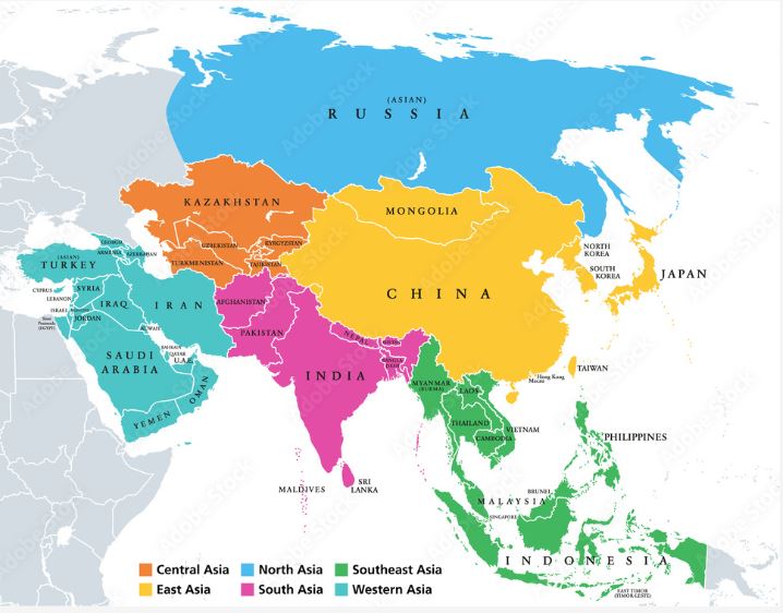
The political map of Asia depicts large parts of Asia with the exception of some countries i Western Asia and the Middle East.
Asia is the largest of the world’s continents. It constitutes nearly one-third of the Earth’s landmass and lies north of the equator except for some Southeast Asian islands. Asia is connected to Africa by the Isthmus of Suez (Egypt) and borders Europe (which is part of the same landmass) along the Ural Mountains and across the Caspian sea.
Asia has a coastline in the north at the Arctic Ocean, in the east at the Pacific Ocean and in the south at the Indian Ocean. The political map shows the countries of Asia along with their capital cities, major cities, islands, oceans, seas and gulfs.
Physical Map of The Asia :-
A physical map of Asia shows the relief features of the continent in shaded form. Perhaps the most striking feature of the map is the dark brown region southern China, which indicates high elevation of the Kunlun Montains, the Plateau of The Tibet and the Himalayan Mountains. These features were formed millions of years ago, when the Indian land mass collided with Eurasian plate.
Asia Can be divided into five major physical regions Mountain systems, plateaus, Plains, steppes, deserts, freshwater environments and saltwater environments
एशिया का राजनीतिक मानचित्र पश्चिमी एशिया और मध्य पूर्व के कुछ देशों को छोड़कर एशिया के बड़े हिस्से को दर्शाता है।
एशिया विश्व के महाद्वीपों में सबसे बड़ा है। यह पृथ्वी के भूभाग का लगभग एक-तिहाई हिस्सा है और कुछ दक्षिण पूर्व एशियाई द्वीपों को छोड़कर भूमध्य रेखा के उत्तर में स्थित है। एशिया स्वेज (मिस्र) के इस्तमुस द्वारा अफ्रीका से जुड़ा हुआ है और यूराल पर्वत और कैस्पियन सागर के पार यूरोप (जो उसी भूमि का हिस्सा है) से घिरा है।
एशिया की तटरेखा उत्तर में आर्कटिक महासागर, पूर्व में प्रशांत महासागर और दक्षिण में हिंद महासागर में है। राजनीतिक मानचित्र एशिया के देशों को उनकी राजधानियों, प्रमुख शहरों, द्वीपों, महासागरों, समुद्रों और खाड़ियों के साथ दिखाता है।
एशिया का भौतिक मानचित्र :-
एशिया का भौतिक मानचित्र महाद्वीप की राहत विशेषताओं को छायांकित रूप में दर्शाता है। संभवतः मानचित्र की सबसे उल्लेखनीय विशेषता दक्षिणी चीन का गहरा भूरा क्षेत्र है, जो कुनलुन पर्वत, तिब्बत के पठार और हिमालय पर्वत की उच्च ऊंचाई को इंगित करता है। इन विशेषताओं का निर्माण लाखों वर्ष पहले हुआ था, जब भारतीय भूभाग यूरेशियन प्लेट से टकराया था।
एशिया को पाँच प्रमुख भौतिक क्षेत्रों में विभाजित किया जा सकता है: पर्वतीय प्रणालियाँ, पठार, मैदान, सीढ़ियाँ, रेगिस्तान, मीठे पानी का वातावरण और खारा पानी का वातावरण।